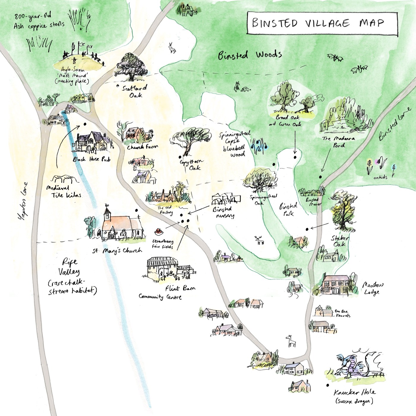
Here is a map of Binsted. There wasn’t room for every house. But it gives a sense of how the village and its history fits together.
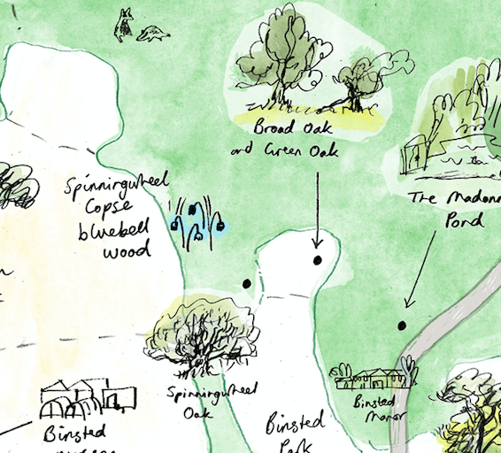
The Oaks run down diagonally from near top left: Scotland Lane; Copythorn; Spinningwheel; Staker. (Broad and Green are off doing their own thing in a clearing beside the woods.)
The dotted lines show the footpaths that weave through the village, following brooks and hedgerows, linking field with wood with lane, and connecting Binsted by foot to its neighbouring towns, villages and countryside.
Scotland Lane itself is an ancient track that may have been used to bring animals to medieval ‘Forest courts’. It leaves the woods to meet Binsted Lane in the village’s north-western corner. Here you can see the Moot Mound, an Anglo-Saxon meeting place.
The Moot Mound sits at the head of the Binsted Rife valley. The valley’s rife (stream) is marked in blue. (Alongside it – not marked on the map – runs the Iron Age earthwork known as War Dyke, atop which Binsted Church sits).
Following the lane down from the Moot Mound you come to the ‘Y’ where Hedgers Hill meets Binsted Lane. This area was once known as All the World, where excavated mediaeval tile kilns speak of an industrious past. The fuel to fire these kilns likely came from the 800-year-old Ash coppice stools located at the top of the valley.
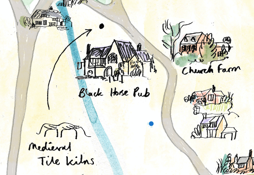
Down the Lane is the Black Horse. A heart of the community for generations, the pub sheltered villagers during WW2, and was the scene of Music Hall sing-alongs in more peaceful times.
Another community focal point lies around a couple of turns in the lane. St Mary’s Church. This 12th Century building has served the village and surrounding parish for almost 900 years, and continues to do so.
Church and pub both boast beautiful views across the Rife Valley to the west, a wonderful place to watch the sun set. There are the remains of a Roman villa on the valley’s far side.
A footpath heads that way (beware golf balls) – you get a good sense of the Iron Age earthwork when you look back at the church from the valley floor.
Or from St Mary’s you could head east, up the Muddy Lane footpath, and cross the fields towards Spinningwheel Copse and the bluebell woods. Look out for the Waymarker, a carved village guardian, and for deer and badger ways through the flowering hedgerow.
Up ahead, the wide woods are calling.
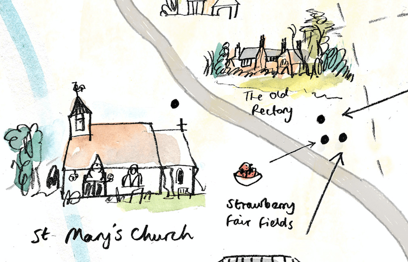
Or start again at St Mary’s, and choose the winding route. Down Binsted Lane is the old Flint Barn, where villagers gather each autumn for the Harvest Supper. Beyond it are the Strawberry Fair fields – visitors to Binsted have enjoyed this (usually) sunny family event for over 30 years.
Now, past homes, businesses and farmland, you come to Binsted Lane’s quiet lower loop. Here, a path leads across marshy ground, out towards Tortington and Ford and the coastal plain. To take it, you will have to pass the watery lair of a dragon known as the Binsted Knucker.
This folkloric serpent recalls a topographic past. Once, Binsted was surrounded on three sides by marshland. It explains why, centuries ago, Saxon and medieval tenant farmers laid out their dwellings along the looping Binsted Lane.
If you follow the Lane round on its way towards the woods, you will catch glimpses, through trees and houses, of the beautiful South Downs, folding away to the east.
The lane becomes wilder, now. More puddle than paving, in places. Traversable by only the hardiest vehicles.
Pause at the Madonna Pond. The Bloomsbury Set affiliate and Binsted resident Lorna Wishart made the shrine which gave this place its name. It is a good spot to contemplate Binsted’s long legacy of art and poetry: Lorna’s spirit lives on in the annual Binsted Arts Festival, a celebration of the area’s cultural life.
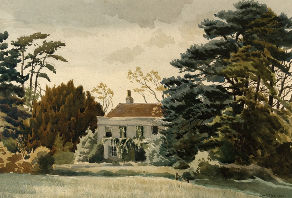
Linger longer and you might sense other energies in the air. The pond, like the old Binsted House that stood near it, is the locus of many a ghost story and strange sighting.
We could walk out west here through the woods of Tortington Common towards Arundel and the wide expanse of the watermeadows. Or, at last, we could loop around the pond and enter Binsted Woods.
Some of the woods are Ancient; all of the woods are precious. There are paths through them in all directions. (Find your way back to Scotland Lane and you can complete your loop of the village.)
And there are other shapes in the ground beneath the trees – boundary ditches, wells, clay and chalk pits, the footprints of old cottages. One path was laid out in the 19th Century as a ‘Lover’s Lane’. It leads to the wide expanse of Binsted Park, a legacy of Victorian landscaping.
These broad-leaf woods – all 250 acres of them, the largest of their kind on the West Sussex coastal plain – open out to wild clearings on their western edge, reminders of the ‘common land’ farming practices of the past. Wild flowers such as wood anemone and purple orchid await the walker.
We won’t say where Lorna’s Secret Garden is (because we’ve never found it) or where the dormice or the barn owls are nesting (because they like to keep themselves to themselves).
But sit for a while, a deer may come. There are badgers and bats, rare butterflies. Rabbits and foxes and birds of prey. Woodpeckers, hedgerow birds, hornets and grasshoppers.
At the heart of the map is the Spinningwheel Oak. Great grandparent of the village, for centuries it has watched over this community of villagers and wildlife. We hope it will do so for centuries more.
But now we turn to another version of the map:
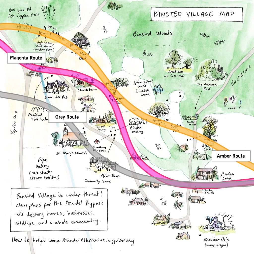
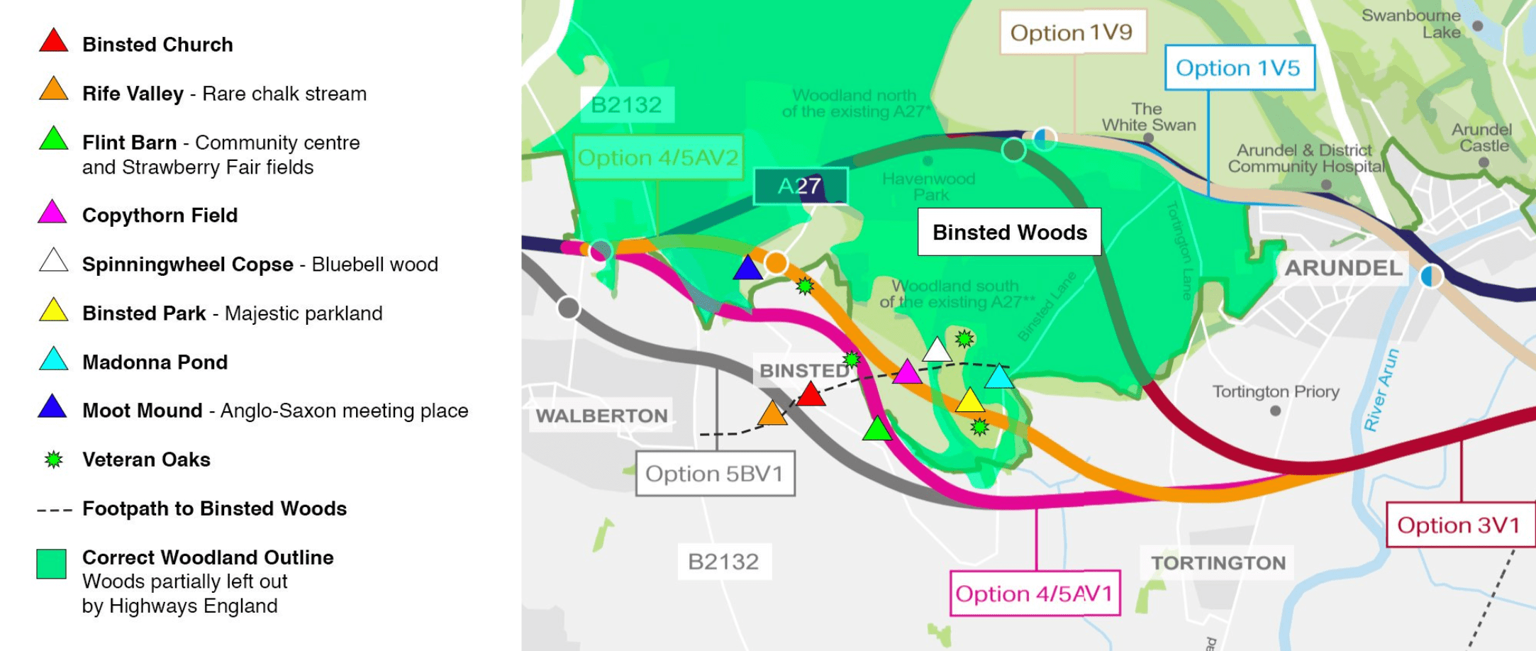
The Magenta route of the proposed A27 Arundel Bypass is a 70MPH dual carriageway that rents the village in two and destroys much of what we have walked through. The ripping up of the Copythorn Oak would symbolise the destruction of a living village community and its connection to the past.
Two other 70MPH dual carriageway proposals go through Binsted. Just to the north of Magenta, the Amber route again tears the village in two. It would damage Staker and Scotland Lane Oaks. To the south, the Grey route would truncate the horseshoe of Binsted Lane and carve up the Rife valley, just south of St Mary’s Church.
All of Highways England’s proposed routes are needlessly destructive. The wrong direction for the 21st Century.
But, as it always has done, the Binsted community – and its community of neighbours in Walberton, Tortington, Arundel and elsewhere – is coming together to fight this road.
Find out how to help here:
And, if you can, come and walk in this peaceful, special place.
For more detail on Binsted’s history, community and wildlife, please read this blog post: What Makes Binsted Special

Leave a comment